


Havre, Montana. The place where Jess and Laurena (Jesmer) Angstman settled and raised their family.
Havre, Montana. The place where Jess and Laurena (Jesmer) Angstman settled and raised their family. They were part of the Great Western Expansion. This include 4 articles on the history and the character of Havre and pictures of Havre Montana to let you know the area that they settled in.
Link to the Jesmer family history page Link to more documents on Sidney and Minnie
Link to Sidney’s Main page Link to Jess and Laurena (Jesmer) Angstman main page
Link to Joseph A. Jesmer page (Sidney’s parents) How the Jesmers came to Minnesota
Link to pictures of Princeton MN in Sidney’s day Hx of Greenbush township where Sidney grew up
From Wikipedia, the free encyclopedia
Havre is a city in Hill County, Montana, is said to be named after the city of Le Havre in France, although this is disputed by some inhabitants. The area was originally known as Bullhook Bottoms. The population was 9,621 at the 2000 census. It is the county seat of Hill County GR6.
Located in north central Montana, it was incorporated in 1893. It was founded primarily to serve as a major railroad service center for Great Northern Railroad (built by James J. Hill) with its location midway between Seattle and Minneapolis-St. Paul. A statue of Hill stands near the Havre Amtrak station to commemorate the key contributions his railroad has made to Havre’s and Montana’s history.
The Milk River (tributary of the Missouri River) runs through the town, and the Bears Paw Mountains can be seen to the south.
Small grids of purple colored squares can be seen in some of the sidewalks in the downtown area (on the north side of the city). These are skylights for a sort of underground “mall” built in the city at least a hundred years ago. Throughout its history, this underground area has been host to a brothel, a Chinese laundromat, a saloon, a drugstore, at least three opium dens, and rooms used for smuggling alcohol during Prohibition. The underground area, now designated “Havre Beneath the Streets”, currently operates as a small tourist attraction.
The Wahkpa Chu’gn buffalo jump, or bison kill, is located behind the Holiday Village Shopping Center near the northwest corner of Havre. Over 2,000 years old, it is one of the largest and best preserved buffalo jumps anywhere. In prehistoric times, Native Americans would drive bison over the edge of the cliff, killing or severely injuring the animals. Afterwards, the Native Americans skinned the animals and preserved the meat. The buffalo jump is now an archaeological site and a small tourist attraction.
The buffalo jump is located at the southern edge of the Havre Badlands, a badlands formation that runs alongside the Milk River to the west of the city. Small fossils, including seashells and petrified wood, can be found in the limestone sediment in this area.
Six miles southwest of Havre is Fort Assiniboine, which served as one of Montana’s principal military posts from 1879 through the Prohibition era. The fort was one of many used by the United States to protect against potential attacks from Native Americans and to block incursions from Canada. At its peak, the fort housed and employed 489 soldiers in 104 buildings.
Also near Havre is the Bears Paw Battlefield site of the Battle of Bears Paw Mountain, where the Nez Perce were attacked and defeated by the U.S. Cavalry. Chief Joseph surrendered to the Cavalry and making a famous speech ending with the line, “From where the sun now stands, I will fight no more forever.”
http://en.wikipedia.org/wiki/Havre,_Montana
History of the Havre Train Route
The development of the Montana Hi-Line region can trace its roots back to the Great Northern Railway. While some settlers had made their way out before the railroad arrived by a bumpy and seldom used trail, the Hi-Line region of Montana lay virtually undeveloped until the GN railroad arrived.
The Great Northern Railroad was the creation of James J. Hill. Hill had an idea of stretching a railroad across the northern tier of the United States to the Pacific Ocean, with a dream of having substantial trade with the Orient. Hill had been thinking about this creation of the railroad for quite some time, and had stockpiled material at rails end, which was then Minot, North Dakota.
Beginning in 1887, the railroad began construction across the Northern Great Plains. The railroad entered Montana for the first time in June of 1887, and averaged 5-8 miles per day in laid track. Initially, the Great Northern Railroad was poised to angle south through central Montana as a pass had not been located in the northern part of the state. But, as fate would have it, one of his engineers, during the horrible winter of 1887-1888, came across Marias Pass. The discovery of this pass led to the railroad bypassing Great Falls, although a branch line was built to the city.
The railroad arrived in Havre in October of 1890 and in Cut Bank in January of 1891. From there, the railroad continued building, eventually reaching the Pacific Ocean in January of 1893.
The Great Northern Railroad, not surprisingly, had a huge effect on what is now the Hi-Line region of Montana. The railroad moved thousands and thousands of farmers and ranchers into Montana – and then moved out the crops they raised. Numerous towns began to grow up on the railroad, acting as a supply point and transportation point for the areas remote farmers and ranchers. How important of a role the railroad played in the development of the Montana Hi-Line is quite evident just by looking on a map of Montana today. On what is now US Highway 2 (created after the railroad arrived and which parallels the railroad closely), there are numerous towns – frequently less than 10 miles apart from each other. Yet, if you head north or south of the highway, you’ll find few towns of any size.
The boom days of the Hi-Line region, like other plains area throughout the United States, occurred during the 1920’s. During that time, more and more settlers poured into the prairie to start their own farms. The weather also cooperated, generally, allowing for dry land crops to grow with abandon.
Yet, things would soon change. The Depression of the 1930’s caused a drop in demand for products. Property values fell with the decline of the US economy. And, if that wasn’t enough, the fearful drought of the mid-1930’s swept through the Great Plains, causing many farmers and ranchers to go out of business. As such, the process of agricultural consolidation, where farms and ranches get bigger and bigger by buying out the land of other farms and ranchers, began during the 1930’s – and continues on to this day.
Yet, even though the Hi-Line region was hit hard by the depression and the drought, the creation of Fort Peck Lake as a giant public work project in the 1930’s brought in a ton of new people and money, if only temporarily. Other public work projects throughout the Hi-Line region also provided a small benefit to other Hi-Line towns.
The 1940’s saw resurgence, economically, in the Hi-Line region. World War II and post-war reconstruction led to resurgence in demand for US crops, putting the local farms and ranches on sound financial footing. Additionally, a very large US Air Force Base was built in Glasgow which provided significant employment during and immediately after World War II. During the 1940’s and lasting up until the early 1960’s, the Hi-Line region, while it didn’t exactly prosper, managed to generally retain and often times grow their economies and population.
Then, things began to change. Beginning in the late 1960’s, the agriculture industry began to accelerate the process of consolidation due to difficult economics and advances in mechanization, leading to fewer people working on ever larger ranches and farms. The town of Glasgow was hit hard by the closure of the Air Force Base. And, as the United States entered a period of stagflation in the 1970’s, the economies on the Hi-Line more or less followed suit.
Well, this is a very short history of the Montana Hi-Line region in general. It is far from complete. But should at least give any visitor to this part of Montana an idea what drove growth in this part of Montana. The rest of the pages in this site will explore what the Montana Hi-Line is like today.
http://www.bigskyfishing.com/Montana-Info/Hi-Line/history-hi-line.shtm
Havre, Montana : A Guide
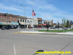
Havre is the largest town on the Montana Hi-Line, with a population of 9600 people, and serves as the retail and business hub of the area. Havre is located more or less “midway” down the Hi-Line. Because of this, Havre is a popular stop for travelers – especially since it is only about 3 hours away from Glacier National Park. Additionally, unlike many other Hi-Line towns where US Highway 2 manages to avoid the downtown areas, in Havre, the highway plows right through town. As such, visitors to the Hi-Line area will get a first-hand look at the downtown area.
And happily, Havre has a pretty nice downtown. Most of the buildings in the downtown area have been restored and renovated to some degree. The downtown and residential areas outside of it are also full of trees, reflecting the foresight by previous town leaders of Havre.
Havre has avoided the population decline problem that has befallen many of the other communities on the Hi-Line. There are several reasons for this. First, its central location on the Hi-Line has allowed the town to function as the business hub of the region, attracting regional businesses (not just town specific ones) that serve the whole area.
Secondly, the Burlington Northern Santa Fe Railroad has a major rail yard in town, providing many well paying jobs. Havre is also the location of Montana State University-Northern, the only College in the Hi-Line area. As such, Havre has developed a diversified economy that most of the other Hi-Line towns in Montana have not been able to develop.
And finally, Havre’s central location on the Hi-Line has led to some growth in businesses that cater to the passing motorist and tourists who are on their way to Glacier National Park and other areas in Montana.
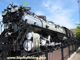
Great Northern Railway Steam Engine at the Train Station
Havre has a sizable business district, both in the downtown area and on the towns edges. The downtown area is full of local businesses that provide one service or another. The downtown area also has a great movie theatre called the Cottonwood Cinemas, a 4-plex. While it doesn’t look like much on the outside, the theatre has been recently renovated on the inside, with some of the theatres having stadium seating – something that is highly unique on the Hi-Line.
More businesses are located on the perimeter of the town, particularly on the western side along US Highway 2. Here you’ll find a very small shopping mall, the usual assortment of fast food joints and restaurants that cater to the passing motorist, as well as the only big box store on the Hi-Line, a Super K-Mart.
Many people first see Havre from the train. Havre is the second busiest Amtrak stop in Montana. Because the train has a re-fueling stop in town, the train generally lays over for at least 20-30 minutes, giving people on the train time to get out and explore a bit. Located right at the train station in Havre is a beautiful Great Northern Railway Steam Engine. Anyone who likes railroad history will most definitely want to take a look at it, as the engine is in perfect condition.
Contrary to popular belief, Havre actually has a pretty nice location for people who like outdoor recreation. Granted, people just passing through on US Highway 2 are unlikely to notice it. But, for the more adventurous, there is no shortage of outdoor activities just outside of Havre.
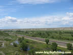
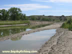
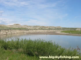
The Milk River just outside of Havre
The angler will find quality trout fishing in Beaver Creek, Bear Paw Reservoir and Beaver Creek Reservoir, all of which are located south of town in and around the Bears Paw Mountains. The Milk River also passes through town and can provide for some decent warm water fishing in spots. And Fresno Reservoir, located about 15 miles to the northeast of town, has excellent fishing for Northern Pike.
Hunters will also find some great places to hunt around town. The Bears Paw Mountains have excellent deer and elk hunting, as do the nearby Sweet Grass Hills. Additionally, the vast fields around Havre provide excellent upland bird hunting.
Additionally, a small ski area called Bears Paw Ski Area is also located in the Bears Paw Mountains and is open on the weekends when there is enough snow.
Overall, Havre is a pretty nice little town that sits in the middle of the Hi-Line region. The town has a diversified economy, a university and a good location for people who like outdoor recreation. Moreover, like other Hi-Line towns, the costs of living are low – with housing prices being very reasonable – and far less than what is found in the mountainous areas of the state.
http://www.bigskyfishing.com/Montana-Info/Hi-Line/havre.shtm

Interact with us using Facebook